REVIEW · OAHU
18 Minutes PRIVATE Helicopter Tour in Honolulu
Book on Viator →Operated by Honolulu Helicopter Tours · Bookable on Viator
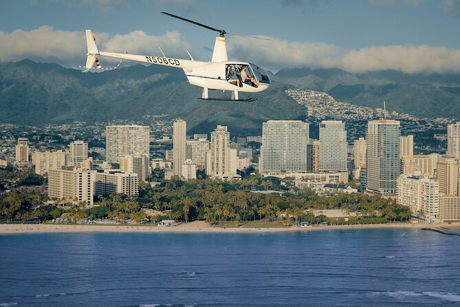
Honolulu looks like a model from the sky. This private helicopter tour gives you a birds-eye view of Honolulu’s big-name sights, with your pilot’s narration coming through clearly thanks to the included aviation headsets.
I love how fast you get the lay of the land: Diamond Head, Waikiki, and the harbors all show up in one tight loop. The other big plus is the option to fly doors off at no extra charge, so you can choose between comfy and thrill.
The main drawback is simple: you’re in the air for about 18 minutes, so this is a taste, not a long scenic cruise. If you want hours overhead, plan on something longer elsewhere.
In This Review
- Key highlights worth planning around
- Finding your starting point at HNL (Lagoon Dr area)
- Private helicopter flight basics: headsets, pilot talk, and doors off
- The 18-minute loop over Diamond Head and Waikiki
- Sand Island, Honolulu Harbor, and the working side of Oahu
- Ala Moana Beach Park, Magic Island, and Ala Wai Harbor
- Waikiki from a different angle: beaches, harbors, and city blocks
- Diamond Head again: crater views and quick aerial context
- Ala Wai Golf Course and the shift from coast to city
- Punch Bowl Cemetery and Honolulu Downtown views from above
- The H201 Interchange: when highways look like maps
- Price and value: is $269 per person worth it?
- Weather, timing, and how to protect your experience
- Who this helicopter tour fits best
- Should you book this Honolulu private helicopter flight?
- FAQ
- FAQ
- How long is the helicopter flight?
- What does the tour cost?
- Is this a private tour?
- Where do I meet for the tour?
- Are aviation headsets included?
- Can I fly with the doors off?
- What landmarks will we see?
- Is there a weight limit?
- What if the weather is bad or I need to cancel?
Key highlights worth planning around
- Private flight, just your group for a calmer pace and more personalized attention.
- Headsets included so you can actually hear the pilot’s guidance instead of guessing.
- Optional doors off for free, which is a rare add-on perk.
- Diamond Head and Waikiki in one loop, with shoreline views from above.
- Plenty of landmarks packed into one short ride, from harbors to downtown.
Finding your starting point at HNL (Lagoon Dr area)
Your trip starts and ends back at the meeting point at 1 Lagoon Dr, Honolulu, HI 96819. Since the tour centers on Honolulu International Airport (HNL), expect the whole experience to feel airport-adjacent in pacing and atmosphere, quick, organized, and geared for taking off fast.
This location matters because it sets you up for a straightforward day. You’re not dealing with a bus ride to some remote launch area, and you won’t lose your whole vacation morning just getting to the helicopter.
If you’re coming from Waikiki, give yourself enough buffer time. Airport-area traffic can slow things down, especially in the late morning and early afternoon. A little padding keeps you from arriving rushed.
You can also read our reviews of more private tours in Oahu


Private helicopter flight basics: headsets, pilot talk, and doors off
This is a private tour/activity, meaning only your group rides together. That’s a big deal when you’re paying for a helicopter: you’re not forced into a rigid group rhythm, and it’s easier to ask the pilot for what you want to see.
You’ll get aviation headsets and a cell phone lanyard. Headsets are essential here. Without them, helicopter noise turns everything into guesswork. With them, you can catch the pilot’s explanations as you pass over landmarks like Diamond Head and Waikiki.
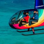
Then there’s the signature choice: doors optional. The tour offers the option to fly with the doors off at no additional charge. For me, that’s where the helicopter really becomes a full-sensory experience, more wind, more sound, and a more dramatic feeling of being right in the view. If you’d rather keep things calmer, you can leave the doors on and still get those same birds-eye angles.
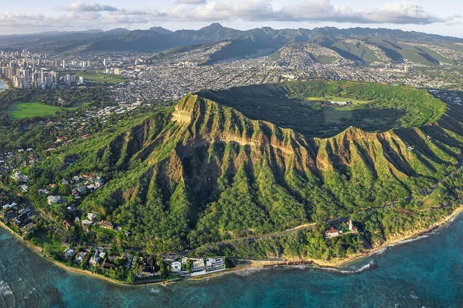
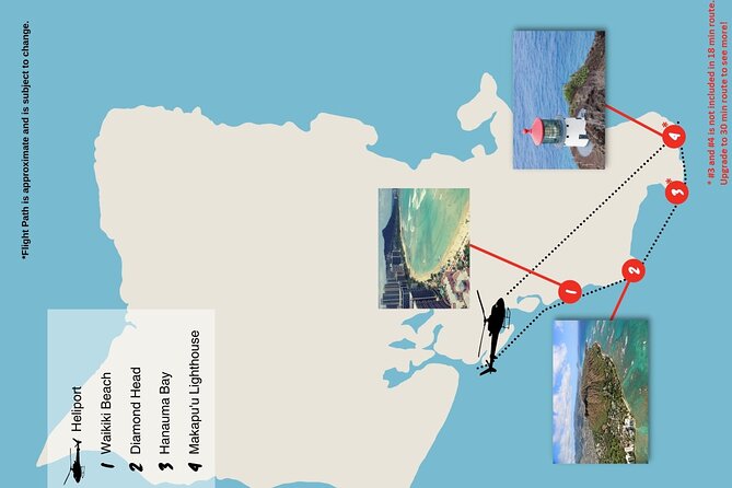
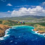
The 18-minute loop over Diamond Head and Waikiki
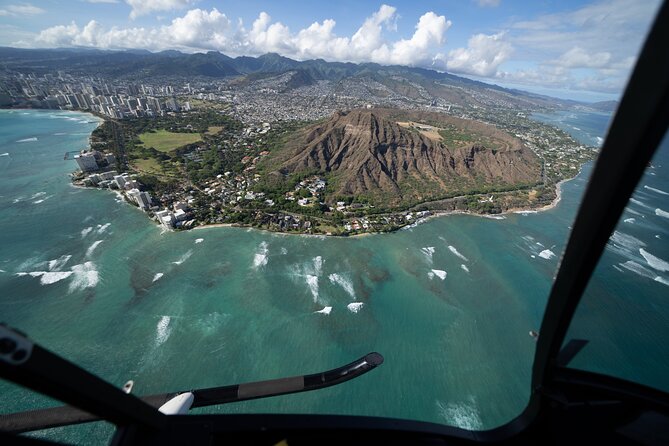
The flight is about 18 minutes long, and the routing is designed to hit the big scenic hits quickly. You start at HNL, then glide over Diamond Head’s volcanic tuff ring and Waikiki. The idea is to get you that fast “I get it now” moment where the island stops being a map and becomes a place.
From above, Waikiki Beach and the shoreline come into focus in a way you just can’t replicate from ground level. You can see how the coast curves, where the built-up areas sit, and how close the neighborhoods feel to the ocean.
You’ll also get a clear view of the Diamond Head Lighthouse, built in 1899. Seeing an old landmark like that from the air gives you scale and context. It’s not just a photo object; it becomes a point on a coastline, tied to the crater’s shape and the surrounding city blocks.
Because the time is short, the pilot’s route aims for maximum variety. You’ll pass over urban Honolulu and Downtown again on the way back, so you don’t just get beach views, you get city structure too.
Sand Island, Honolulu Harbor, and the working side of Oahu
After launch, you pass over Sand Island and Honolulu Harbor. This part of the route is valuable because it shows Honolulu as more than resort beachfront.
From the air, harbor areas make everything look organized and functional, the geometry of piers, the spread of port spaces, and the way boats and shoreline meet. Even if you’ve driven past these spots on the ground, seeing them from above helps you understand how the island operates.
If you like photography, this section tends to deliver clean visual lines. Harbors and islands offer straight edges, curves, and strong contrast between water and structures. With only 18 minutes total, this is one of those “use your eyes fast” stretches.
One practical note: if you’re going doors off, water reflections can get intense. Protect your phone and camera gear from wind-driven spray and expect glare on bright days.
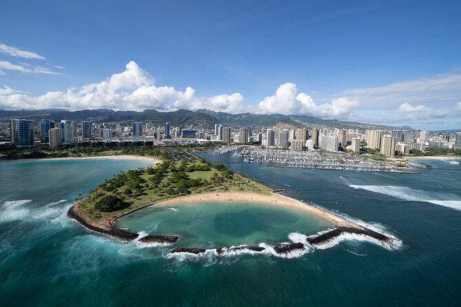
Ala Moana Beach Park, Magic Island, and Ala Wai Harbor
Next up you’ll see Ala Moana Beach Park, Magic Island, and Ala Wai Harbor. This is the sweet spot for readers who want both beach energy and a more lived-in island feel.
From above, these locations help you connect the dots between Waikiki’s hotel zone and the wider coastline. Ala Moana reads differently from the air than it does when you’re walking it: instead of a beach you visit, it becomes part of a larger coastal system.
Magic Island and Ala Wai Harbor add variety. They’re the kind of landmarks that make your aerial photos look less like one generic coastline shot. They also show how quickly recreational areas blend into the city’s infrastructure.
If you’re the type who likes to build a mental map while you travel, this portion helps. After you’ve seen it from overhead, you’ll recognize the shapes instantly when you return to the ground.
You can also read our reviews of more tours and experiences in Oahu
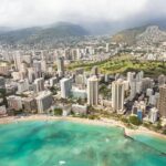


Waikiki from a different angle: beaches, harbors, and city blocks
When you’re flying over Waikiki, the key advantage isn’t just the view. It’s the geometry. You can see the shoreline with one continuous perspective, then watch the city grid appear in the background.
That matters because Waikiki can feel dense and confusing at street level. From the air, it’s easier to understand where the beachfront zone ends and where the city starts. You get a bird’s-eye “map overlay” that stays with you.
Also, having doors off as an option changes how you experience Waikiki overhead. Without the door, the view feels wider and more immediate. Even if you’re not chasing adrenaline, it’s a distinct way to feel connected to the ocean edge instead of separated by glass or a door frame.
If you’re planning your sightseeing after the flight, you’ll probably find it easier to choose which areas to explore on foot. You’ve effectively done a quick orientation tour.
Diamond Head again: crater views and quick aerial context
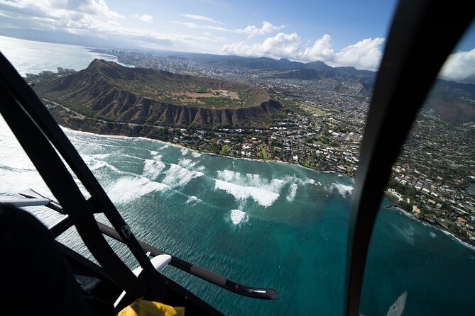
Diamond Head is repeated in the routing, and that makes sense. It’s one of Oahu’s most recognizable shapes, and it acts like a visual anchor for the whole region.
You’ll glide over Diamond Head and see the tuff ring, which helps you grasp the crater’s outline. Then you’ll catch the famous lighthouse detail. Put together, it’s a quick lesson in how this volcanic landmark sits right next to major neighborhoods.
This is where I’d pay attention to where the crater edge meets the urban area. That boundary shows up clearly from above and helps explain why Waikiki has that distinctive look of close-by hills behind the coast.
Ala Wai Golf Course and the shift from coast to city
As the route moves inland, you’ll pass over Ala Wai Golf Course and then continue toward Honolulu Downtown. Seeing a golf course from the air is surprisingly useful. The fairways and course layout stand out, and you can spot how it sits among housing and roads.
This transition matters because it changes the visual story of your flight. You go from ocean and shoreline to structured, planned land use. If you’re traveling with someone who likes city sights, this segment gives them something to look at too.
It also helps you understand that Honolulu isn’t just beaches and hotels. There’s major infrastructure and planned spaces right in the same view frame.
Punch Bowl Cemetery and Honolulu Downtown views from above
Later in the flight you’ll see Honolulu Downtown and Punch Bowl Cemetery. These are the kind of landmarks that feel important in real life, and from the air they become markers of where the city’s identity turns.
From above, Punch Bowl Cemetery looks distinct because of the way it’s set into the landform and city context. The aerial angle makes you see it as part of a larger neighborhood pattern, not just a stop on a route.
With Honolulu Downtown, you get the compact grid feeling and the main arteries of city movement. Even if you don’t memorize street names, you’ll likely understand how areas connect. This is one of those practical benefits of helicopter travel: it makes your later ground navigation feel less random.
The H201 Interchange: when highways look like maps
You’ll also fly over the H201 Interchange. Highways and interchanges are usually hard to picture from the ground because you’re always moving through them.
From above, they turn into clear geometric shapes. You can see how roads feed into each other and how they connect neighborhoods to the airport area and main coastal stretches.
This section is especially helpful if you’re renting a car. After an overhead view like this, you’ll probably have an easier time picturing where you are in relation to major routes.
Price and value: is $269 per person worth it?
At $269 per person, this isn’t a budget activity. But it is a classic value play in a specific category: short, high-impact sightseeing with a private setup.
Here’s why it can be worth it for the right traveler:
- You get a private helicopter experience rather than sharing your seat with strangers.
- You get 18 minutes of flight time designed to cover major landmarks in one pass.
- You get doors off as an option with no extra charge, which adds a big feeling-of-place upgrade.
- The headsets make the narration workable, so you don’t just sit there trying to interpret a moving postcard.
Where it may not feel like value:
- If you’re sensitive to cost or you mainly want photos, you might feel 18 minutes is too short.
- If you’re expecting a long, detailed tour of every area, this one is built for speed and highlights.
My practical advice: if this is your first time in a helicopter and you want a fast way to see Honolulu from the air, it’s easier to justify. If you already know the island’s layout and only want a single beach shot, you may prefer a less expensive alternative.
Weather, timing, and how to protect your experience
This flight requires good weather. When conditions aren’t right, the operator will offer a different date or a full refund. That’s not a small detail, because ocean area flights can be affected by wind and visibility.
So plan around flexibility. If you can, build in a time window in your schedule rather than locking in the only available day. The good news: you choose from several flight times to fit your schedule, which helps you find a weather-friendly slot.
Also keep your expectations aligned with the timing. You’re not buying a full-day aerial tour. You’re buying a focused overhead loop, and it will feel best when you treat it like a highlight moment in your day.
Who this helicopter tour fits best
This 18-minute private helicopter tour makes the most sense if you want:
- A fast orientation to Honolulu (Diamond Head, Waikiki, harbor areas, downtown all show up).
- A comfortable first-time helicopter experience with pilot-led guidance through headsets.
- The option of doors off for a stronger thrill without paying extra.
- A private flight with only your group, so the experience feels personal.
It may not fit if:
- You’re looking for something long and slow with lots of time to linger over one spot.
- You’re traveling with someone who exceeds the 300 lbs total weight per passenger limit.
Should you book this Honolulu private helicopter flight?
If your goal is to see Honolulu’s highlights in one shot, Diamond Head, Waikiki, harbors, and downtown, this is a smart, efficient use of money and time. The private setup, headset narration, and free doors-off option are the kind of details that turn a short flight into the main event.
I’d book it if you want a memorable first helicopter experience and you’re okay with 18 minutes in the air. Skip it if you need a longer tour length or you’re very price-sensitive.
FAQ
FAQ
How long is the helicopter flight?
The flight is about 18 minutes (approx.).
What does the tour cost?
It costs $269.00 per person.
Is this a private tour?
Yes. It’s a private tour/activity, so only your group participates.
Where do I meet for the tour?
You meet at 1 Lagoon Dr, Honolulu, HI 96819, USA. The activity ends back at the meeting point.
Are aviation headsets included?
Yes. Aviation headsets are included so you can hear the pilot.
Can I fly with the doors off?
Yes, doors are optional, and you can fly with the doors off at no additional charge.
What landmarks will we see?
You’ll have a chance to see Sand Island, Honolulu Harbor, Ala Moana Beach Park, Magic Island, Ala Wai Harbor, Waikiki, Diamond Head, Ala Wai Golf Course, Honolulu Downtown, Punch Bowl Cemetery, and the H201 Interchange.
Is there a weight limit?
Yes. The total weight per passenger is 300 lbs.
What if the weather is bad or I need to cancel?
The experience requires good weather. If it’s canceled due to poor weather, you’ll be offered a different date or a full refund. You can cancel up to 24 hours in advance for a full refund.