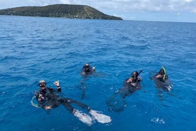
REVIEW · OAHU
30 Minutes SHARED Helicopter Tour in Honolulu
Book on Viator →Operated by Honolulu Helicopter Tours · Bookable on Viator
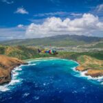
One quick look down, and Oahu feels brand-new. I love that this small-group 30-minute helicopter ride turns big landmarks into clear, easy-to-understand viewpoints. I also like the pilot-led commentary, which helps you connect what you’re seeing with where you are and why these places matter. The main drawback to consider is the tight time window: it’s short, so you’ll want to be ready to look, shoot, and listen right away.
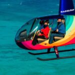
This is set up for an easy, friendly experience with up to three travelers, plus aviation headsets and a cell phone lanyard so you can keep your hands free for photos. You’ll get a smooth flight over a route that mixes coastline, beaches, neighborhoods, and major roads, with a final return to the meeting point near HNL.
In This Review
- Key things to know before you go
- Why this 30-minute shared helicopter ride works in Honolulu
- Price and what you really get for $319
- The flight route above Oahu: what you’ll see from takeoff to landing
- Waikiki, Ala Wai, and the oceanfront “layers”
- Diamond Head and the volcanic silhouette
- Waialae Country Club: big greens from above
- Downtown Honolulu and Aloha Tower area
- Punchbowl Crater and the National Memorial Cemetery
- The freeway maze: H201 interchange and the H3 corridor
- Moanalua Gardens: a park you can actually spot
- Aloha Stadium and the industrial edge of the map
- Black Point Sea Pools and the coast details
- Pilot commentary, headset comfort, and door-off photos
- Comfort, weight limit, and the weather reality
- Who should book this helicopter tour (and who might skip it)
- Should you book this 30-minute shared helicopter tour over Oahu?
- FAQ
- How long is the helicopter tour?
- How much does the tour cost?
- How many people are on the flight?
- Where does the tour start and end?
- What’s included in the tour?
- Is the tour offered in English?
- Is this a mobile ticket?
- What is the passenger weight limit?
- What happens if weather is bad or you need to cancel?
Key things to know before you go
- Maximum three travelers means you’re not packed in, and it feels more like a shared flight than a cattle-car tour
- Aviation headsets included make the pilot’s directions and commentary much easier to hear
- Most booked about a month out (around 32 days on average), so grab your date sooner than later
- A route built for photos takes you over Waikiki, Diamond Head, the harbor areas, and punchy inland spots like Moanalua Gardens
- Weight limit is 300 lbs per passenger, so check that early to avoid disappointment
- Good weather is required, and poor-weather cancellations can lead to a reschedule or a full refund
Why this 30-minute shared helicopter ride works in Honolulu
Honolulu from the air is not just pretty. It’s useful. When you look down from above Waikiki, Diamond Head, and the harbor, the whole island suddenly makes sense, where the mountains start, how the coastline bends, and why certain neighborhoods feel close together even when the roads say otherwise.
What I like most is the tour’s balance: it’s long enough to hit a wide swath of Oahu, but short enough that you don’t spend half your vacation waiting around. At roughly 30 minutes, the flight is built for one thing, views, without turning into an all-day event.
Also, this is a shared tour, but it’s not crowded. With a maximum of three travelers, you’re more likely to get that calm, focused atmosphere where you can actually pay attention to the pilot’s narration and coordinate your photos.
One other practical upside: you’re in English, and the pilot role matters here. On a flight like this, seeing is half the job. Hearing context is what makes the sights click into place.
You can also read our reviews of more tours and experiences in Oahu

Price and what you really get for $319

At $319 per person for a shared 30-minute flight, this isn’t a budget activity. The value comes from four places:
- Time compression. You’re getting a lot of “where am I and what am I looking at?” moments in half an hour.
- Small group size. Up to three travelers keeps the experience feeling personal rather than rushed by crowds.
- Included comfort gear. You get an aviation headset and a cell phone lanyard, which matters because you’ll be moving from takeoff to photography fast.
- Photo-friendly routing. The path is set up to show you coastline angles, shoreline contrasts, and landmark shapes that are hard to match from the ground.
If you’re trying to choose between a helicopter ride and a bunch of paid ground activities, this is the one that changes how you see Oahu. It’s not about checking off a list; it’s about getting a new mental map.
The flight route above Oahu: what you’ll see from takeoff to landing

The tour starts and ends at HNL, and the route is designed as a loop of big visuals. Think of it like a fast aerial highlight reel, with the pilot guiding you through what’s coming next.
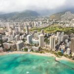
Waikiki, Ala Wai, and the oceanfront “layers”
As you head over the shoreline areas, you’ll get a layered view of how Waikiki meets water, marinas, and the city core. Expect sweeping looks at:
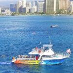
- Honolulu Harbor: You’ll see it from above as the state’s principal seaport, a major working piece of Oahu’s daily life. From the air, the scale of piers and the mix of shoreline uses becomes obvious.
- Ala Moana Beach Park: This long stretch of public beach sits between Waikiki and downtown. Aerial views are perfect here because you can grasp the park’s footprint, over 100 acres and a wide, golden-sand beach.
- Magic Island: This man-made peninsula adjacent to Ala Moana and the Ala Wai Yacht Harbor is one of those places that looks almost like an idea made physical. From above, you’ll see how it sits like a connector between water zones.
- Ala Wai Harbor: From the sky, you can read the layout, between Waikiki and downtown, with Magic Island to the east side of the harbor view.
Waikiki is usually busy from the ground. From above, you’ll see the neighborhood’s shape and the beachfront rhythm more clearly, plus Diamond Head looming nearby like a visual anchor.
Drawback to keep in mind: in a short flight, the coastal sections come quickly. If you’re hoping to study beach details for a long time, you’ll want to choose your moments and keep moving with the pilot’s cues.
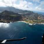
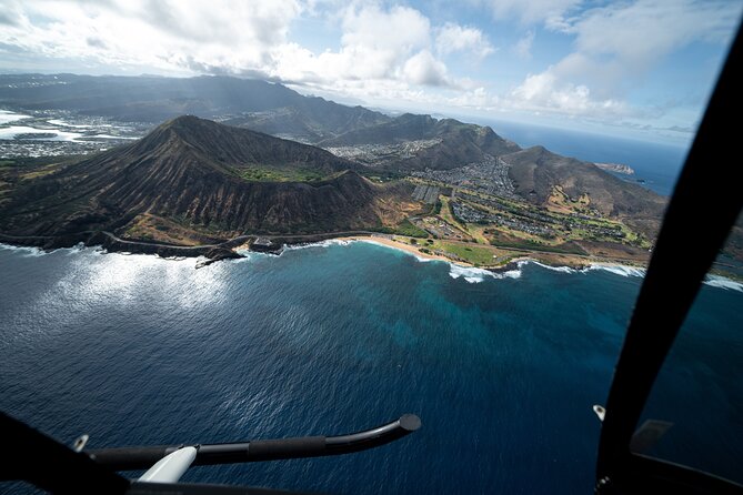
Diamond Head and the volcanic silhouette
Next up is Diamond Head (Lēʻahi), a volcanic tuff cone. What makes it satisfying from the air is its geometry: the ridgeline shape reads instantly, and the Hawaiian name adds a layer of meaning because the shape is often linked to the look of a tuna’s dorsal fin.
From the sky, Diamond Head also helps you orient yourself. You can use it like a landmark compass: when you see it, you know you’re in the Waikiki–east Honolulu orbit.


Waialae Country Club: big greens from above
You’ll pass over Waialae Country Club, a private club in East Honolulu. From the air, the golf course becomes a grid of greens, fairways, and water hazards (where present), and the surrounding neighborhoods look different too, less like streets and more like patterns.
If you’re the kind of traveler who likes context, here’s what makes this spot more than just a big property: it was founded in 1927 and designed by Seth Raynor. It’s listed as a par 72 championship course, which adds to why it’s such a distinctive, deliberate-looking layout from overhead.
Downtown Honolulu and Aloha Tower area
Then you’ll move over Honolulu Downtown, Hawaii’s political and business hub. The aerial value here is spacing: you can see how the city core stacks against water and how the streets funnel toward the shoreline.
You’ll also be in range of Iolani Palace from above, plus the Hawaiʻi State Art Museum area. On the waterfront side, Aloha Tower Marketplace and Aloha Tower itself (the 1920s landmark) are the kind of structures you can spot quickly from a helicopter window.
Practical photo tip: city-to-ocean edges often produce the best shots because they give you a horizon line and a contrast between buildings and water.
Punchbowl Crater and the National Memorial Cemetery
One of the more powerful moments on the route is the aerial look at The National Memorial Cemetery of the Pacific at Punchbowl Crater.
From above, you get a strong sense of the crater’s shape and the way the memorial fits into the terrain. It’s not just a sightseeing stop. It’s the kind of place that changes your tone mid-flight because it’s meant for remembrance.
The freeway maze: H201 interchange and the H3 corridor
Later in the loop, the route heads toward major road systems, including:
- H201 Interchange (you’ll see the connection points from above, like a traffic diagram laid on the island)
- H3 Highway (John A. Burns Freeway): you’ll cross the Koʻolau Range along viaducts and through tunnels, include Tetsuo Harano Tunnels at 5,165 feet long and smaller Hospital Rock Tunnels
If you like infrastructure, this is where the helicopter makes its case. From the ground, freeways can feel like fast blur. From the air, you see how the island forces engineering to bend around the landscape.
Moanalua Gardens: a park you can actually spot
Then you’ll get views over Moanalua Gardens, a 24-acre privately owned public park. This stop is especially interesting because it includes specific points you can search for visually from above:
- Kamehameha V Cottage, formerly the home of Prince Lot Kapuāiwa (who became King Kamehameha V)
- The Prince Lot Hula Festival site
- A large monkeypod tree, known in Japan as the Hitachi tree
Even if you don’t recognize every detail in the moment, the aerial perspective makes it clear why it’s considered a distinct space rather than just “some green patch.”
Aloha Stadium and the industrial edge of the map
Finally, you’ll fly over Aloha Stadium in Halawa. It’s described as a closed multi-purpose stadium and the largest stadium in Hawaii. The details that stand out: it ceased fan-attended operations indefinitely as of December 2020, and there’s a moratorium on scheduling new events.
From above, the stadium is still easy to pick out because big stadium footprints are unmistakable. This part of the loop gives you a contrast between entertainment venues and the surrounding neighborhoods.
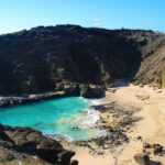
Black Point Sea Pools and the coast details
You’ll also see Black Point Sea Pools along the route. From above, the “sea pools” concept reads as a shoreline feature you can’t easily understand from a street-level walk. It’s the kind of sight that makes you realize the coast is doing more than sitting there, it’s shaping water movement.
Pilot commentary, headset comfort, and door-off photos
This tour’s real secret ingredient is the pilot’s ability to narrate. The best flights are the ones where the pilot doesn’t just point out landmarks, they help you understand what you’re looking at while it’s still in your frame.
You’ll also appreciate the aviation headsets included. That one detail makes a noticeable difference because helicopter noise can drown out casual conversation.
On photo setup: if you’re excited about sharper shots, consider what you’ve heard about flying with the doors off. Some pilots and aircraft configurations can make that possible, and people strongly encourage it for the photo results. I’d still treat it as a “ask and confirm” item for your specific booking, because rules and aircraft setups can vary.
What you can plan for: great photo angles across Waikiki, Diamond Head, and the harbor areas, plus quick aerial reads of inland routes like H3 and Moanalua Gardens. In 30 minutes, photo success is about timing, not perfection.
Comfort, weight limit, and the weather reality
A few practical things can make or break your day.
- Weight limit: 300 lbs per passenger. Check this before you commit so you don’t end up with a last-minute snag.
- Good weather is required. If the flight is canceled due to poor conditions, you’ll be offered a different date or a full refund. That means you should try to schedule this with flexibility in your itinerary, ideally not on a day when you absolutely must be on the ground for other plans.
- Most travelers can participate, but you’re still dealing with a short aircraft ride and noise levels, so if you’re sensitive to heights or motion, think through how you handle those situations.
Included gear helps: the cell phone lanyard is one of those small items that prevents you from accidentally juggling your device while you’re trying to shoot.
Who should book this helicopter tour (and who might skip it)
This tour fits best if you:
- Want a bucket-list aerial view without losing half a day
- Like big landmarks with real context from the pilot
- Prefer a small group experience where you can hear instructions and focus on the view
- Are traveling with someone who enjoys photography and wants clear angles that are hard to replicate from the ground
You might skip it if you:
- Need a longer time on each sight. This is a loop tour, and it moves
- Want guaranteed photo time and slow sightseeing. The aircraft schedule and route pace drive the experience
- Have rigid plans on a specific weather-dependent day
Should you book this 30-minute shared helicopter tour over Oahu?
Yes, if you want the fastest path to seeing Oahu in one connected picture. At $319 per person, it’s not cheap, but the short duration + small group + pilot narration + included headset gear make it feel like a high-focus experience rather than a long, complicated day.
Book it if you’re the type who gets more excited by maps, shapes, and layout than by wandering around. Skip it if you’d rather spend that money on ground activities that let you linger.
If you decide to go, do this: pick your date with weather flexibility, arrive ready to look and shoot quickly, and ask your pilot what door setup you should expect for your specific flight.
FAQ
How long is the helicopter tour?
The flight is about 30 minutes.
How much does the tour cost?
The price is $319.00 per person.
How many people are on the flight?
This is a shared tour with a maximum of 3 travelers.
Where does the tour start and end?
It starts at 1 Lagoon Dr, Honolulu, HI 96819, USA, and it ends back at the meeting point.
What’s included in the tour?
You receive an aviation headset and a cell phone lanyard.
Is the tour offered in English?
Yes. The tour is offered in English.
Is this a mobile ticket?
Yes. It includes a mobile ticket.
What is the passenger weight limit?
The total weight per passenger must be 300 lbs or less.
What happens if weather is bad or you need to cancel?
The tour requires good weather. If it’s canceled due to poor weather, you’ll be offered a different date or a full refund. For cancellations by you, it says you can cancel up to 24 hours in advance for a full refund; within 24 hours, it’s not refunded.