REVIEW · OAHU
Blue Skies of Oahu Helicopter Tour
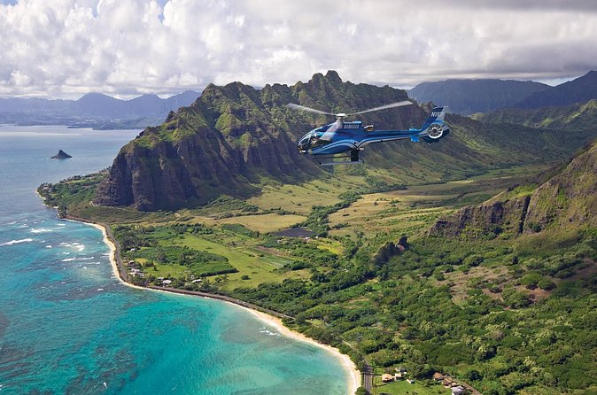
Book on Viator →Operated by Blue Hawaiian Helicopters - Oahu · Bookable on Viator
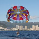
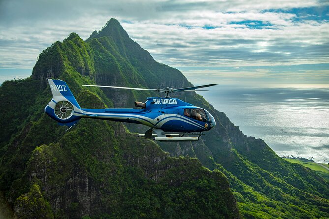
Flying above Oahu beats staring at maps. In about 50 minutes, Blue Skies of Oahu stitches together Pearl Harbor, Waikiki, and the North Shore into one photo-friendly loop, powered by an Eco-star helicopter and paired with Bose aviation noise-cancelling headsets and 2-way audio.
What I like most is how the pilot guide calls out sights in real time (you’re not stuck with silence), and how the aircraft design keeps views clear from the windows. One thing to consider: motion sensitivity is real, and if weather is rough or visibility is low, the scenery you wanted can look less dramatic.
In This Review
- Key things to know before you fly Blue Skies of Oahu
- Blue Skies of Oahu helicopter tour: what you’re really buying for $438.90
- Where you meet and what to plan for on arrival
- Seats, headsets, and the pilot guide: why the narration is part of the value
- Pearl Harbor from the air: USS Arizona and the memorial sites
- Honolulu to Waikiki: city geometry plus coastline
- Diamond Head (Lē’ahi): the iconic cone seen from the sky
- Lē‘ahi to the waterline: marine preserve views and snorkeling-bay energy
- Lanikai and Kailua: the “Best Beach in America” vibe from above
- Kāneʻohe Bay, Heʻeia Pond, and the protected-water playground effect
- Private ranch-country scenery and an air-only kapu waterfall
- North Shore surf country: the 7-mile miracle and the surf-town feel
- Price and value: why this can be worth it (and when it’s not)
- Practical tips that actually help during the flight
- Who should book Blue Skies of Oahu, and who might skip it
- Should you book the Blue Skies of Oahu helicopter tour?
- FAQ
- How long is the Blue Skies of Oahu helicopter tour?
- Where is the meeting point, and when should I check in?
- What’s included in the price?
- What should I wear or avoid bringing?
- What is the weight requirement?
- How many people are in each tour?
- Are children allowed?
- Is there a scuba diving restriction?
- What happens if weather cancels the tour, or if I cancel?
Key things to know before you fly Blue Skies of Oahu
- Small group size (max 6 passengers) helps the experience feel personal and keeps the aircraft calmer.
- 2-way headset communication means you can actually hear what’s happening and ask quick questions.
- Pilot guide is State of Hawaii Certified, you get more than landmark spotting.
- Route varies with wind and weather, so focus on regions, not exact overflight timing.
- Bring dark clothing and skip hats/bags/large cameras for smoother check-in and better photo results.
- If you’re over 240 lbs, you’ll need a half-price extra seat for safe balance.
Blue Skies of Oahu helicopter tour: what you’re really buying for $438.90
At about 50 minutes, this is one of those rare Oahu tours that hits a lot of the island without asking you to drive for hours. The price, $438.90 per person, is steep, but it’s also for something you can’t replicate on the road: a true aerial line of sight over water, coastline, and reef areas. If you’ve ever tried to plan multiple beaches and historic sites in a single day, this flight is what your schedule wishes it could do.
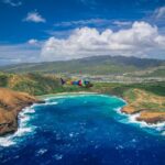
The itinerary is built around geographic “anchors.” You start with Pearl Harbor, move through Honolulu and Waikiki, then swing to Diamond Head and into Oahu’s windward side. After that you see marine areas and beaches like Lanikai, and you wrap up with Kāneʻohe Bay and the North Shore, including surf-coast views often linked to the idea of the 7-mile surf legacy.
Duration matters here: you don’t get stuck on a long tour bus timeline, and you’re back where you started at the same meeting point. You’re basically paying for high-value sightseeing time, compressed, scenic, and usually with smooth, non-stop flight pacing.
You can also read our reviews of more tours and experiences in Oahu

Where you meet and what to plan for on arrival

This tour starts at Blue Hawaiian Helicopters, 99 Kaulele Pl, Honolulu and ends back at that same meeting point. Check-in happens 45 minutes before your tour time, which is not just paperwork. That window is for weight check, safety briefing, and getting you seated on time.
Plan like the airport mindset applies, even if it’s not an airport: traffic can slow you down, and late arrival can mean you might not be accepted (and the booking is non-refundable if you miss the window). If you want the easiest day, arrive early and treat check-in as part of the experience, not a chore.
Also note: the tour runs on conditions. Wind and weather can change routes and timing, so the key is to show up flexible. You’re buying aerial coverage of Oahu’s highlights; the exact minute-by-minute overflight can shift.
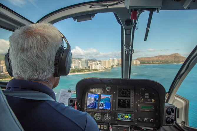
Seats, headsets, and the pilot guide: why the narration is part of the value
The “feel” of this helicopter tour is driven by three practical choices.
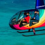
First, you get Bose Aviation-grade, electronic noise-cancelling headsets. Rotor noise is the usual headache on any helicopter ride. Better headsets mean less strain and clearer audio, especially when you’re listening for historical context.
Second, you’re given microphones with 2-way communication with the pilot. That small detail changes the tour. You’re not just watching from a distance, you can interact, react, and follow along while the pilot adjusts for sightlines.
Third, the pilot is also a State of Hawaii Certified Tour Guide. In plain terms, you should expect more than names of places. You’ll get explanations you can actually use, why sites mattered, what you’re seeing from above, and what makes each part of the island different.
From the stories I’ve heard around this operator, pilots such as Markus, Alex, and Benjamin are often praised for keeping the ride smooth and for turning the aircraft so passengers on both sides get a good view of major points. That matters more than people think. A helicopter tour isn’t just “where you fly”, it’s also who can see what.
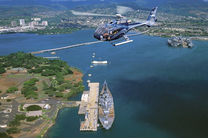
Pearl Harbor from the air: USS Arizona and the memorial sites
You begin at Pearl Harbor in Honolulu, with the USS Arizona Memorial. From above, it’s not just the scale that hits you, it’s the pattern of the harbor and the sense of how concentrated the attack was. The memorial marks the resting place of 1,102 of the 1,177 sailors and Marines killed aboard USS Arizona on December 7, 1941.
Next, you pass over the Pearl Harbor National Memorial area at Joint Base Pearl Harbor-Hickman. The memorial includes nine historic sites tied to the Pacific war experience. Aerial views help you understand layout: where you’d otherwise see only buildings and shorelines, you get a “whole scene” perspective.
This is the part of the tour that tends to feel most meaningful. It’s also the segment where weather can matter most, because contrast and clarity make the memorial area feel crisp instead of hazy. If conditions are overcast, you still see the basics, but the visual punch may be reduced.
Honolulu to Waikiki: city geometry plus coastline
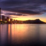
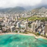
After Pearl Harbor, the flight heads toward Honolulu, described as a cosmopolitan capital with historic landmarks, fine dining, world-class shopping, and the famed Waikiki coastline. From the air, Honolulu reads like a mix of tight urban blocks and long water edges. You’ll likely notice how the neighborhoods grade into beach and resort zones.
Then comes Waikiki, where high-rise hotels line the shore and the area centers around a popular surf beach. Seeing this from above is a reality check: Waikiki looks small on a map, but from the air you can measure how the shoreline shape steers the waves and crowds.
If you’re the kind of person who likes to photograph cities, this is one of your best windows. Just remember: the tour’s rules limit what you can bring into the cabin, so think compact.


Diamond Head (Lē’ahi): the iconic cone seen from the sky
Diamond Head, Lē’ahi, sits right at the edge of Honolulu, and flying past it gives you the “why it’s famous” view. You’re looking at the volcanic cone in a way that’s hard to get from street level, its shape becomes obvious, and you can see how it separates city shoreline from other coastal directions.
This stop also tends to work well for first-timers. Even if you don’t know much Hawaiian geography, the mountain becomes a visual landmark you can mentally anchor. If you like orientation, this is where your brain starts to map Oahu quickly.
For better photos: wear dark colors to avoid reflections on the windows, and skip hats. Those instructions aren’t just for style, they help with image quality in the cabin.
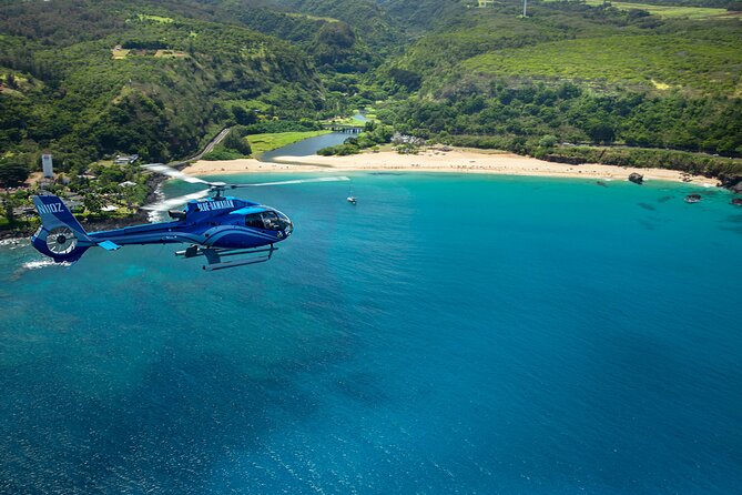
Lē‘ahi to the waterline: marine preserve views and snorkeling-bay energy
The tour continues toward a marine preserve formed within a volcanic cone, described as bustling with marine wildlife, plus reef patterns that make it a premier snorkeling spot. From the air, these bays often look like color gradients, shallow areas lighten, deeper areas darken, and reef contours show up like faint lines under the surface.
This is the segment that sells the idea of Oahu’s underwater geography to people who only know beaches. If you love snorkeling (or just wish you did), aerial views make it easier to understand why certain coves are protected and how water movement changes what you see.
A practical note: the tour includes no mention of wet weather gear. Still, you’ll be more comfortable if you dress for a cool cabin. Helicopter air can feel chilly once you’re seated, even in Hawaii.
Lanikai and Kailua: the “Best Beach in America” vibe from above
The itinerary includes Lanikai Beach, described as consistently named the Best Beach in America. From the air, the reason is pretty straightforward: clear water and white sand create a strong color contrast that’s hard to fake on land.
Then you get Kailua on Oahu’s windward, East side. Kailua is known for beaches with gentle waves and clear water, plus the nearby Mokuleia Islands about a mile off the coast, which provide sanctuary for Native birds. Aerial coverage helps you grasp how Kailua’s coastal curve and the offshore islands relate to each other, again, it’s about layout and scale.
If you’re hoping for that “this looks like a postcard” moment, this is often where it happens. Just be ready for the fact that cloud cover reduces saturation, so aim to book a time slot that matches your patience for changing light.
Kāneʻohe Bay, Heʻeia Pond, and the protected-water playground effect
Next comes Kāneʻohe Bay, called the largest sheltered body of water in the islands and a recreational playground. The standout visual detail here is the large sandbar that creates colorful bands. From above, those bands can look almost painted, like the bay has layers.
You also see Heʻeia Pond along the shore, where ancient Hawaiian fishing traditions remain alive and well. Even if you don’t know the exact practices, aerial views give you context: you can tell where a managed pond sits in relation to open water and shoreline.
This is another segment where weather influences what you feel. On clear days, you get crisp color and strong outlines. On gray days, you still see the shapes, but the bay’s “layered” look may soften.
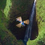
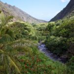
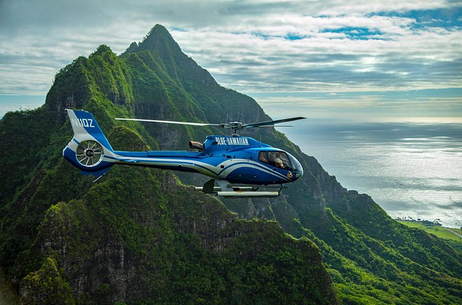
Private ranch-country scenery and an air-only kapu waterfall
One of the most intriguing parts of this tour is the stop at a private nature reserve and working cattle ranch with popular movie filming locations, spread across over 4,000 acres. You’re seeing land used as working terrain and as cinematic backdrop, another reminder that Oahu isn’t only beaches and towns.
Then you fly past a 1,100 ft waterfall described as kapu, forbidden, and only accessible by air. The “only accessible by air” detail is key. It signals that you’re not just seeing a viewpoint waterfall, you’re seeing a landscape that’s kept off-limits to foot access, which makes the aerial perspective feel more exclusive.
A gentle caution: waterfall visibility can depend on conditions. One account noted that the falls were a bit disappointing when overcast. That doesn’t mean you’ll be let down, but it’s a heads-up that light and cloud cover affect how dramatic water looks from above.
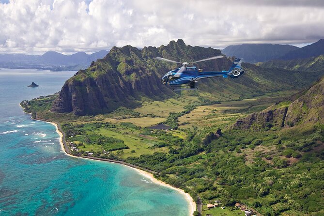
North Shore surf country: the 7-mile miracle and the surf-town feel
Finally, you head to the North Shore, tied to the idea of the 7-mile miracle, world-famous surf created by expansive reef formations along the coast. The aerial viewpoint is perfect for this because reefs and shoreline shape influence where waves form. From the air, you can often “read” the coastline the way surfers feel it.
The route also includes a historic surf town on the North Shore, known for unique eats, shops, and a laid-back vibe. Even without getting off the aircraft, you can see the town’s footprint against the coast, and you’ll spot the mix of commercial spots and beach-adjacent streets.
This ending is a good emotional landing: you’ve started with solemn history and moved toward surf culture. For many people, it feels like the tour’s reward scene, big coastline, big energy, and wide-open views.
Price and value: why this can be worth it (and when it’s not)
Let’s be real: $438.90 per person is not a casual add-on. You’re paying for:
- Time compression (lots of regions in one shot)
- Aerial access to places that are either hard to reach by car or hard to “see” from the ground
- Included equipment: Bose headsets, 2-way communication, and the pilot guide experience
- Small capacity (max 6), which often leads to better attention and fewer crowd distractions
So when is it worth it? If your Oahu plan already includes Pearl Harbor plus a scatter of beaches and viewpoints, this helicopter tour can replace a day of driving and reduce the risk that one “must-see” ends up crowded or blocked by traffic.
When it’s not worth it? If you’re mainly after one beach view, you might be better off spending less time and money on a simpler shoreline activity. Also, if you’re extremely sensitive to motion or you’re likely to be disappointed by weather-based variation, the helicopter experience may feel like a gamble. On the plus side, the operation does require good weather, and if the flight can’t run due to conditions, you should expect a different date or a full refund.
Practical tips that actually help during the flight
A few details make a big difference on helicopter day:
- Wear dark colored clothing to reduce reflections in photos.
- Don’t bring hats, bags, large cameras, or extending selfie sticks. They’re not permitted in the cabin.
- Bring a credit card if you want optional in-flight video/photo packages sold after the flight and any souvenirs at the heliport.
- Keep your body ready for a short, bright ride: one reason people take it with care is motion sensitivity. If you know you get sick in cars or boats, it’s smart to prepare ahead of time.
- If you’ve been scuba diving, there’s a rule: no scuba diving within 24 hours of departure.
And if weight is a factor: the tour sets a 240 lb total passenger limit. If you’re over, you’ll need an adjacent empty seat for safe balance. That adjacent seat is half off and needs to be arranged after booking.
Who should book Blue Skies of Oahu, and who might skip it
This tour fits best if you want a single flight that covers multiple “Oahu priorities” without needing a full day on the road. It’s also a strong choice for couples and families who want a high-impact activity that’s still structured and easy to follow: check-in, safety brief, then sit back while the pilot connects the dots.
It’s not the best fit if:
- You dislike height or you’re very motion sensitive.
- You have a strict schedule and can’t handle weather-dependent route adjustments.
- You’re traveling light and don’t want to follow cabin rules about equipment.
But if you’re flexible and you want the kind of viewpoint you can’t duplicate from a lookout, this is a solid use of your time.
Should you book the Blue Skies of Oahu helicopter tour?
I think it’s a “yes” for most first-time Oahu planners who care about Pearl Harbor, coastline, and the windward-to-North-Shore sweep. The value comes from the combination of included headsets + 2-way communication + a certified pilot guide, plus the small-group size that helps the experience feel focused.
Book it if you:
- Want one activity that covers a lot of island variety
- Appreciate aviation narration, not just sightseeing
- Are okay with the fact that weather and wind can affect what you see
Hold off if you:
- Can’t manage motion discomfort
- Only want one small area of the island
- Don’t want any route variability
If you’re aiming for an efficient, memorable highlight reel of Oahu from the air, Blue Skies of Oahu is one of the best ways to do it.
FAQ
How long is the Blue Skies of Oahu helicopter tour?
It runs for about 50 minutes.
Where is the meeting point, and when should I check in?
You meet at Blue Hawaiian Helicopters, 99 Kaulele Pl, Honolulu, HI 96819. Check in 45 minutes prior to your tour time.
What’s included in the price?
Included are Bose aviation-grade electronic noise-cancelling headsets, microphones for 2-way communication with the pilot, a pilot guide who is also a State of Hawaii Certified Tour Guide, and all fees and taxes.
What should I wear or avoid bringing?
Wear dark colored clothing to help reduce reflections in photos. Hats, bags, large cameras, and extending selfie sticks are not permitted. If you want optional video/photo packages, bring a credit card.
What is the weight requirement?
The total weight per passenger is 240 lbs. If you weigh over 240 lbs (108 kg), an adjacent empty seat is required for safe balance, and that second seat is half off.
How many people are in each tour?
This activity has a maximum of 6 travelers.
Are children allowed?
Children 23 months and younger are complimentary and considered a lap child.
Is there a scuba diving restriction?
Yes. No scuba diving within 24 hours of departure.
What happens if weather cancels the tour, or if I cancel?
The experience requires good weather. If it’s canceled due to poor weather, you’ll be offered a different date or a full refund. You can cancel for a full refund up to 24 hours before the experience starts. Cancellations made less than 24 hours before don’t get refunded.